
Mastaura
Hidden in a lush valley near Nazilli, Mastaura boasts an extraordinary round Roman amphitheatre akin to Rome's Colosseum.
 Photograph unavailable
Aydın · Valley and passage city
The Mastavra Stream and olive valley
Tucked into a verdant hollow north of Nazilli between Bozyurt and Eycelli, ancient Mastaura straddles the Mastavra Stream, also named Khrysaoris. Ringed by terraced fig and olive orchards, this sheltered valley provided natural protection and abundant freshwater to its ancient inhabitants.
The Colosseum of Anatolia
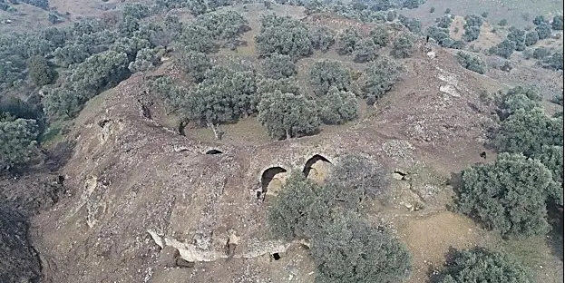
Mastaura's crowning marvel is its newly rediscovered circular amphitheatre, a remarkably preserved provincial cousin to Rome's Colosseum. With vaulted barrel-corridors, subterranean gladiator chambers and radial seating, it represents one of Anatolia's rarest intact arenas.
A pivotal node on the Maeander highway
The ancient artery (Caput Via) sweeping from Ephesus and Miletus through Tralleis and Nysa toward Laodicea traversed Mastaura's doorstep. The city prospered as a commercial transit hub linking Carian uplands with the lush valley floor.
Excitement rising from the soil
Brought to light by ongoing scientific excavations, Mastaura radiates the authentic thrill of archaeological discovery. Free from commercial crowds, this tranquil valley is a sensational stop along the route connecting Nysa and Aphrodisias.
An arena hidden amidst the olives
With its breathtaking circular amphitheatre emerging from hillside olive groves along the Mastavra gorge, Mastaura is the Maeander basin's most captivating archaeological revelation alongside Nysa and Tralleis.
Layers of the place
How is the place situated?
Mastaura lies about three kilometres north of Nazilli in the valley between Bozyurt and Eycelli. Mastavra Stream, also named Khrysaoris in the official record, passes through the city area and makes water and terrain the main line through which to read the settlement.
How do the layers change?
The official historical-geography record places Mastaura alongside directions involving Miletos/Ephesos, Tralleis, Nysa, Hierapolis and Laodikeia. A university report dated 27 September 2022 records that excavations begun that July exposed outer support walls, galleries, vaulted corridors and seating; the two records operate at different timescales.
How was the place inhabited?
Natural passages from the directions of Caria and Lydia meet in the Büyük Menderes valley, placing Mastaura within a geography of movement and connection. This context does not prove that every road functioned simultaneously or that a continuous visitor route exists today.
What can be said today?
The university source provides a dated view of excavation and conservation work observed in 2022, including restorers working on cracks and deterioration. It is not current evidence for access, opening hours, tickets or completed restoration, so present visiting conditions require separate verification.
Connected stops
Stories that include this stop
Sources
Frequently asked questions
Where is Mastaura?
Mastaura is presented in this guide as a valley and passage city in Aydın.
How can I find sources for Mastaura?
The Sources section links to the evidence supporting this dossier.